
our services
Topographic models
Let us provide you a solid starting point for your design project - LiDAR is well-suited to meet your ALTA/NSPS Table A items, topo & other surface needs
LiDAR's unique ability to penetrate dense vegetation and canopies enable highly accurate surface modeling where other methods might contain inaccuracies or data voids. This enables us to build an accurate Digital Elevation Model (DEM), yielding a design-ready bare earth model to include contour lines at intervals ranging from 6" to 100'. Breaklines are included to further increase the contour accuracy. In addition to bare earth models, we can also include surface modeling of buildings, vegetation, roads, water, bridges, and transmission classification in ASPRS schema. LandXML TINs & Hydro-flattened products are also available. An accuracy report is included with every delivery to verify LiDAR data against known surveyed ground points.
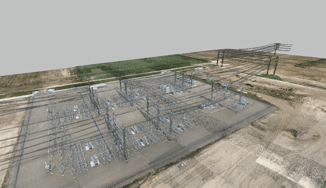


Transmission systems
Cherokee Imaging specializes in modeling of transmission lines and corridors for direct import into PLS CADD (Power Line Systems Computer-Aided Design and Drafting) software. Our UAV & mobile systems are perfect for capturing the fine detail of overhead lines, associated structures, and substation interfaces. We’ll take your specific Feature Code List and deliver in LAS, ASCII XYZ, DXF and .BAK files
Accurate Terrain Mapping: We can provide highly accurate terrain data and planimetrics, allowing for precise modeling of the landscape through which transmission lines will run. This includes capturing the elevation changes, vegetation, buildings, and other features that may affect the placement and design of the transmission lines.
Vegetation Management: LiDAR can detect vegetation density and encroachments along the transmission corridor. This information is crucial for assessing clearance requirements to prevent vegetation interference with the transmission lines.
Structural Analysis: LiDAR data can also aid in assessing the structural integrity of existing infrastructure such as towers, poles, and other support structures along the transmission line route. This information is important for evaluating the suitability of existing infrastructure for supporting the transmission lines or identifying areas that may require reinforcement or replacement.
3D Visualization: Our PLS CADD models provide accurate 3D visualizations of the transmission line corridor. This allows engineers and designers to better understand the terrain and environmental conditions and make informed decisions during the design process.
Efficient Collection: Drone LiDAR technology enables rapid & dense data collection over hundreds of acres per day, making it a cost-effective solution for capturing transmission line routes compared to traditional methods. Minimize your field crew’s time on site and the associated hazards of proximity to energized structures!
2d/3d planimetrics
Planimetric maps show man-made and natural objects outlined with 2D or 3D symbology. This can include parking lots, buildings, utilities, sidewalks, fences, roads, water features, vegetation and building footprints. We provide 2D planimetrics from rectified orthomosaic imagery or 3D planimetrics from LiDAR point cloud data; or a combination of both for detailed urban mapping requirements.
We’ll utilize your specific feature code list or standard mapping libraries for products ranging from 1”=20’ to 1”=500’ scale products.
Sample 2D planimetric data

volumetrics
Highly accurate site volumes are critical throughout all phases of any earth movement or mining operation project. This assists project managers with progress payments, mining yields, and site change management. Volume measurements are typically accurate within 1-2% of traditional ground-based laser measurements. Density calculations are also available for various substrate materials involved. These measurements are invaluable tools to manage site status and third-party progress verification. Deliverables can be tailored to your project budget ranging from a report-only format or include a full 3D dataset.
orthoImagery
A combined imagery/LiDAR dataset is ideal for most design applications. Whether using UAV platforms to capture ~1” RGB imagery, or manned aerial platforms for larger multi-band requirements, we ensure the data is matched to project specs and integrates seamlessly with all other products for a consolidated dataset. Imagery is color-corrected, spatially adjusted, and orthorectified to correct for lens distortions and apparent changes in the position of ground objects caused by the sensor viewing angle and ground terrain. Imagery will be delivered in industry-standard uncompressed or compressed raster formats (GeoTiff, PNG, jp2, MrSID, ECW) and include the AT/Accuracy report

Check out our sample LiDAR & Imagery
